The cave geology of Lava Beds National Monument is unusually rich because the monument isn’t simply a field of isolated lava tubes. It is a stacked, three-dimensional volcanic plumbing system preserved on the northern flank of Medicine Lake volcano. The caves record how successive basaltic lava flows were fed, transported, drained, collapsed, and modified after eruption.


The fundamental setting
Lava Beds lies on the north flank of the enormous Medicine Lake shield volcano. Medicine Lake is a very broad volcano built by numerous eruptions rather than the steep central cone characteristic of Mount Shasta. The monument preserves about 36 eruptive events from Medicine Lake’s roughly 500,000-year history. (National Park Service)
Most of the monument’s caves formed in basaltic lava flows. This is critical: these are primary volcanic caves. The empty space was created during the eruption itself, rather than being excavated later by groundwater. USGS estimates up to roughly 500 known lava-tube caves within the monument, making it one of the world’s exceptionally concentrated lava-tube areas. (USGS)
How the Lava Beds tubes form
The classic Lava Beds tube begins with a fluid basaltic flow.
Imagine a river of molten basalt moving downslope:
                advancing lava flow
             ______________________
           /                        \
          /     cooling crust        \
         /____________________________\
             ↓ molten lava ↓
        ==========================
The surface and margins cool first. The lava underneath remains molten and continues flowing. Eventually the crust becomes strong enough to form a roof over the active lava channel. The tube has now become an insulated conduit. USGS compares this process to a stream continuing to flow beneath a progressively freezing ice cover. This insulation is extremely important. Once a tube forms, it allows lava to travel much farther than it could as an exposed flow.
The tube is not necessarily empty while it forms
This is an important point for understanding the cave morphology. During an eruption, the “cave” may be completely filled with molten lava. The process is more like:
open lava channel
→ partially roofed channel
→ closed lava tube
→ lava continues flowing through tube
→ eruption wanes
→ tube drains
→ cave remains
So the cave is essentially the negative space left behind by the lava’s plumbing system.
Why the Lava Beds tubes can become enormous
Once a tube is established, it acts as an insulated pipeline. The lava loses much less heat than it would on the surface, allowing it to remain molten and travel farther. This creates a feedback:
longer flow → more insulation → longer flow → larger tube system
Some flows can therefore transport lava considerable distances from their source. USGS notes that much of both the north and south flanks of Medicine Lake volcano were constructed by lava transmitted through tubes.
The caves preserve the inside of the lava flow
This is what makes Lava Beds particularly valuable geologically. When you’re standing inside one of these caves, you’re looking at structures that formed while the lava was still moving.
Lava shelves and benches
If the lava level drops while the tube remains active, the former lava surface can remain attached to the wall. Repeated changes in lava level produce:
- upper bench
- middle bench
- lower bench
This can tell a geologist that the tube experienced several stages of filling and drainage.
Lava gutters
Flowing lava can carve or construct channels along the floor or walls. These can preserve the direction in which the lava traveled. Consequently, the cave can contain its own paleoflow indicators.
Lava linings
A new pulse of hotter lava can partially remelt or coat the existing tube wall. This can produce smooth, glazed surfaces or additional layers of lava. A tube can therefore contain evidence for multiple pulses of lava through the same conduit.
Lava falls are particularly informative
Where a tube encounters a steep drop, molten lava can cascade downward. After draining, the frozen cascade becomes a lava fall. That tells you something about the geometry of the original lava-flow system.
For example:
UPPER TUBE
───────────────
       \
        \
         \  lava fall
          \
           ─────────────
              LOWER TUBE
The cave is therefore recording an ancient topographic gradient that existed while the lava was flowing.
Roof collapse is what exposes many caves
A tube can remain completely buried beneath the lava-flow surface. Eventually the roof weakens and collapses. That produces:
- entrances
- skylights
- pits
- collapse depressions
- chains of aligned collapses
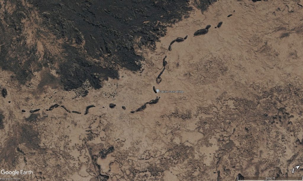
A particularly important geological observation is that a line of collapse pits can reveal the position of a buried lava tube. The surface landscape therefore gives clues to the cave’s underground geometry.
Lava Beds is a multi-generational cave system
This is where the geology becomes much more interesting than the simple “lava tube” explanation. The monument contains lava flows of many different ages. The oldest preserved eruptive event within the monument is the Hovey Point basalt, about 445,000 ± 25,000 years old. (National Park Service) Later eruptions covered portions of those older surfaces. So you can have:
Young lava flow
────────────────────────

     younger tube
       ________
      /        \
_____/__________\_____

Older lava flow
────────────────────────

       older tube
     _____________
____/             \____
A cave can therefore be:
- beneath a younger lava flow
- cut off by a later eruption
- partly buried
- intersected by another tube
- exposed again by collapse
The result is a three-dimensional network of volcanic conduits of different ages.
The major cave systems aren’t necessarily one continuous system
This distinction is important. Seeing hundreds of caves on a map does not mean Lava Beds contains one gigantic interconnected cave. Instead, the monument contains many separate tube systems associated with different eruptions and lava flows. Some tubes are short and simple. Others branch extensively. Some have multiple levels. Some terminate in collapse. Others were probably truncated when the lava supply stopped.
The surface geology tells you where to look underground
The cave systems are strongly related to the surface volcanic features.
The monument contains:
- cinder cones
- spatter cones
- pit craters
- lava-flow margins
- pressure ridges
- collapse chains
- vents
- lava tubes
Most lava flows in the monument originated from cinder and spatter cones within the monument. That means a good geological interpretation often works from the surface downward:
vent
↓
lava-flow field
↓
tube-fed flow
↓
tube network
↓
collapse zone
↓
distal lava-flow terminus
The cave is just the underground portion of that much larger system.
The different lava textures matter
The monument contains a variety of basaltic lava morphologies, including pāhoehoe (pah-hoy-hoy) and ʻaʻā (ah-ah).
Pāhoehoe tends to be more fluid and can develop efficient tube systems. As lava becomes more viscous or develops a rough, broken surface, it can transition toward ʻaʻā. That transition can tell you about changing conditions during an eruption—particularly temperature, discharge rate, cooling, and flow deformation. So even the texture of the lava above and around a cave can help explain how the tube formed.
Water didn’t excavate these caves—but it can modify them
This is an important distinction from limestone cave geology. A typical limestone cave develops because:
water + carbonic acid → dissolution of limestone → cave
A Lava Beds cave develops because:
molten basalt → tube formation → lava drainage → cave
Groundwater and snowmelt subsequently enter some tubes and can produce secondary effects such as:
- sediment accumulation
- breakdown
- mineral coatings
- ice
- biological deposits
- localized erosion
But those processes are modifying an existing volcanic cave, not creating the primary cave.
Ice caves are a special consequence of the geology
Some Lava Beds caves maintain remarkably cold conditions because the cave environment is insulated from the surface. Cold winter air can enter through entrances and cracks, while the surrounding basalt provides thermal insulation. In suitable caves, ice can therefore persist long after winter. The ice isn’t what formed the cave—it is a secondary climatic phenomenon occurring inside the volcanic void.
The cave morphology can tell you the eruption history
This is perhaps the most scientifically useful aspect of Lava Beds. Suppose you find:
- several horizontal lava benches
- a lava gutter
- a lava fall
- multiple wall coatings
- a partially collapsed ceiling
- a lower passage
Together, these features can tell you that the tube experienced multiple stages of lava movement. You can reconstruct something like:
Stage 1: lava enters the tube
Stage 2: tube fills substantially
Stage 3: lava level falls
Stage 4: another pulse raises the level
Stage 5: lava drains
Stage 6: roof partially collapses
Stage 7: later weathering modifies the cave
The cave is consequently a kind of frozen eruption record.
The most useful way to visualize Lava Beds
Rather than imagining the monument as:
“a bunch of caves in a lava field”
Visualize it as:
                    volcanic vents
                   /      |       \
                  /       |        \
             lava flows  lava flows  lava flows
                |          |           |
             tube       tube system    tube
            / | \        / | \          |
           /  |  \      /  |  \         |
        cave cave cave cave cave      cave
          \       collapse pits       /
           \__________________________/
                    older lava
The caves are the preserved conduits inside a succession of lava flows. That perspective explains why the monument has such an extraordinary concentration of caves.
And there is a bigger geological story
The most fascinating thing about Lava Beds is that the caves allow you to study the internal plumbing of Medicine Lake volcano at a scale that is normally impossible. The monument preserves a progression from:
mantle-derived basalt
→ eruption from fissures/vents
→ surface lava flow
→ cooling crust
→ tube formation
→ long-distance lava transport
→ tube drainage
→ roof collapse
→ cave
→ secondary modification
All of that happened repeatedly over hundreds of thousands of years. The National Park Service describes the monument as containing hundreds of well-preserved volcanic features ranging from basalt to rhyolite, while the USGS emphasizes that the lava-tube systems were fundamental to construction of the Medicine Lake shield itself.
Regional cave map
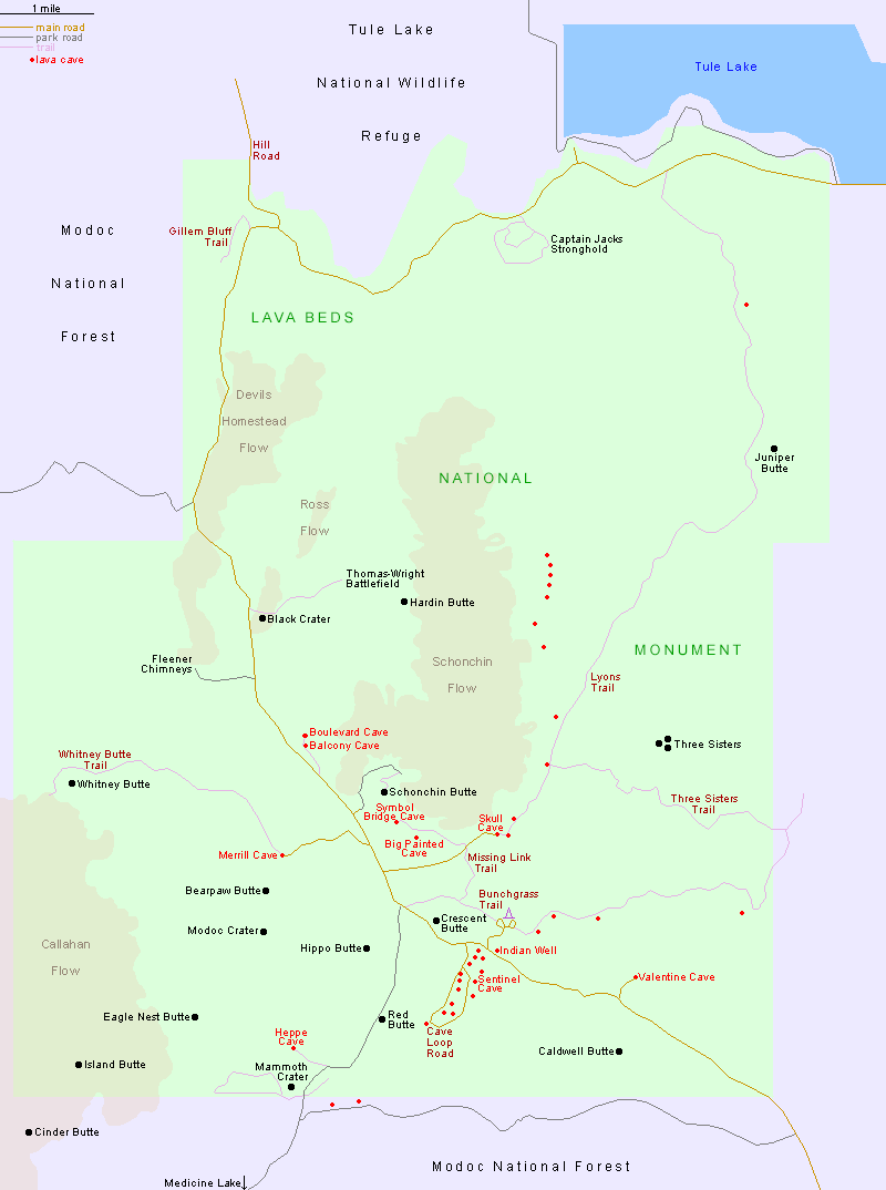

The USGS geologic map is the best regional geological reference; the USGS Cave Loop map is particularly useful for seeing how individual caves connect into tube systems. (U.S. Geological Survey)
USGS geologic map of Lava Beds National Monument
NPS Lava Beds maps, including the Cave Loop and Catacombs maps
Cave regions within the Monument
Mammoth Crater — the principal source area
Location: southern-central part of the monument.
This is the most important place to understand the entire cave field.
Mammoth Crater erupted roughly 30,000–40,000 years ago and produced more than 70% of the surface lava in the monument. Lava traveled northward in multiple braided streams, eventually feeding the extensive tube systems that produced many of the caves farther north. (National Park Service)
Think of Mammoth Crater as the upstream end of a gigantic underground plumbing network:
                 MAMMOTH CRATER
                      │
                 lava supply
                 ╱    │    ╲
               ╱      │      ╲
             tube    tube    tube
              │       │       │
              ↓       ↓       ↓
          Cave Loop / northern lava field
The important geological point is that the cave you’re standing in may be many miles from the vent that produced its lava.
USGS reports that some Medicine Lake tubes transported lava 15–20 miles from their sources. (USGS)
Cave Loop / Headquarters area — the classic tube complex
This is the central-northern concentration of developed caves around the Visitor Center.
The major caves include:
- Mushpot
- Labyrinth
- Lava Brook
- Thunderbolt
- Golden Dome
- Hopkins Chocolate
- Blue Grotto
- Sentinel
- Catacombs
- Ovis
- Paradise Alleys
- Hercules Leg
- Juniper
- Sunshine
The remarkable thing is that these aren’t simply geographically close caves. Several are parts of interrelated lava-tube systems. The classic USGS map shows the complexity particularly well.
Geological significance
This area is an excellent cross-section through a mature lava-tube field. Repeated lava pulses:
- established tubes,
- partially drained them,
- refilled them,
- created new distributaries,
- caused roofs to collapse,
- and buried portions of earlier tubes.
USGS specifically notes that a renewed eruption can refill an existing tube, overflow it, and extend the lava field farther downslope. (USGS) That is why these caves can have multiple levels, complicated junctions, lava benches, and passages that abruptly terminate in breakdown.
Catacombs — the big, complex tube
Catacombs is the standout cave of the Cave Loop area. At approximately 6,903 ft (2.1 km), it is currently the longest cave listed by NPS among the developed/self-guided cave group. Geologically, Catacombs is interesting because it demonstrates how a lava tube can evolve into a branching network rather than remaining a single passage. Its many side passages were the reason J.D. Howard gave it the name “Catacombs.” The floor also preserves excellent examples of pāhoehoe structures, including rafted blocks and ropey lava.
What Catacombs tells us
It’s a good example of the transition:
simple lava tube → branching tube → distributary network → partial collapse
The numerous entrances don’t necessarily represent separate caves in the geological sense. They can be different collapse windows into the same original lava system.
Valentine Cave — an unusually well-preserved tube
Valentine is particularly valuable scientifically because it is comparatively clean and intact.

It’s about 1,635 ft (498 m) long and is famous for its smooth, organic-looking walls and relatively little breakdown. NPS specifically recommends it as an excellent example of the primary volcanic features of a lava tube. The most important feature isn’t necessarily its length. It’s the high-lava marks. These horizontal features record successive levels of molten lava inside the tube. USGS has used Valentine to demonstrate that lava tubes can drain and refill repeatedly during an eruption. This creates a fascinating inversion of normal stratigraphy:
The relatively young lava that flowed through the tube can lie below and against older lava that formed the tube walls.
That’s because the walls cooled first, while younger molten lava continued flowing through the interior. Valentine is therefore one of the best places in Lava Beds to understand how a lava tube actually operates while an eruption is occurring.
Sentinel — a long tube with two major entrances
Sentinel is another important Cave Loop system.
It has Upper Sentinel and Lower Sentinel entrances, which provide access to different portions of the same long tube system. NPS lists it at approximately 3,280 ft (1 km). Geologically, this demonstrates an important principle:
one lava tube ≠ one cave entrance.
As the roof collapses at multiple locations, a single buried tube can become a string of accessible caves. The surface expression might look like:
       collapse        collapse       collapse
          ↓               ↓               ↓

─────────○───────────────○───────────────○────────
          \              / \              /
           \____________/   \____________/
                 lava tube
This is one reason Lava Beds has hundreds of “caves” even though the number of major original lava-tube systems is much smaller. USGS estimates that multiple collapses have created hundreds of accessible cave segments from roughly a dozen major tube systems.
Golden Dome / Hopkins Chocolate / Blue Grotto
These caves are especially useful because they demonstrate different stages and styles of tube preservation within the Cave Loop complex. Golden Dome is notable for its yellowish microbial/mineral coating and substantial passage. Hopkins Chocolate has more challenging crawling and breakdown. Blue Grotto has a more enclosed, developed tube morphology. The important geological lesson is that cave appearance changes dramatically even within the same general lava field because of:
- tube size
- lava discharge
- cooling rate
- number of lava pulses
- roof collapse
- subsequent mineral alteration
Skull, Merrill and the northern/eastern cave field
Moving away from the Cave Loop, you encounter a different group of caves including:
Skull Cave → Merrill Cave → Heppe Cave → Big Painted → Symbol Bridge
These are particularly interesting for thermal and climatic cave development. Skull and Merrill, for example, can maintain cold conditions and historically contained substantial perennial ice. NPS identifies Merrill and Heppe as ice-related caves. The cave itself is still volcanic—the ice is a secondary consequence of cave geometry and airflow.A deep, shaded tube with restricted air exchange can behave almost like a natural refrigerator.
Heppe Cave — southern cave field
Heppe lies farther south, closer to the Mammoth Crater region. It is a relatively short cave—about 170 ft (52 m) of developed passage—but geologically it belongs to the broader southern lava-flow landscape associated with the Mammoth Crater eruptions. It’s useful because it illustrates an important point:
large lava output does not necessarily produce large surviving caves everywhere.
A lava flow can have had an extensive tube system while the present accessible cave is only a small remnant. Roof collapse, later burial, infilling and truncation can destroy most of the original passage.
Schonchin Butte and the Schonchin Flow — a different kind of lava
This is where the geology changes substantially.


Schonchin Butte is a cinder cone, but it subsequently produced a large lava flow. That flow is notably different from the highly fluid Mammoth Crater basalt. USGS describes the Schonchin flow as more viscous, dominated by ʻaʻā and block lava, and consisting of overlapping flow lobes. (NPS History) This is important for cave geology.
Mammoth Crater lava
fluid → pāhoehoe → efficient lava tubes
Schonchin lava
more viscous → ʻaʻā/block lava → thick overlapping lobes
Consequently, the Schonchin area isn’t simply another version of the Cave Loop tube field. It represents a different lava-flow style and therefore different cave-forming potential.
The really important northward pattern
Put the whole thing together:
                         NORTH
                           ↑

                    Tule Lake Basin
                           │
        ┌──────────────────┼──────────────────┐
        │       NORTHERN CAVE FIELD            │
        │   Skull / Merrill / Symbol Bridge    │
        │                                      │
        │        CAVE LOOP COMPLEX             │
        │  Catacombs / Sentinel / Golden Dome  │
        │   Labyrinth / Blue Grotto / etc.     │
        │                 ↑                    │
        │                 │ lava tubes         │
        │                 │                    │
        │            Mammoth Crater            │
        │                 ↑                    │
        │          primary lava source         │
        └──────────────────────────────────────┘
                           SOUTH
This is the crucial geological relationship:
Mammoth Crater → lava flows → tube systems → collapse chains → hundreds of caves
The caves aren’t randomly distributed. They’re the surviving pieces of a large, branching transportation system for basalt. USGS describes the Mammoth Crater lava as forming a broad fan of complexly interfingering flows across the lower northeastern flank of Medicine Lake volcano.
One of the best geological clues: collapse chains
If you’re looking at the landscape from a caver’s perspective, watch for linear strings of collapse pits.
They can represent the buried trace of a tube:
surface

       ○       ○        ○          ○
       │       │        │          │
───────┴───────┴────────┴──────────┴──────

       \____________________________/
             buried lava tube
The collapses don’t necessarily occur directly over the entire tube. But where they do line up, they can reveal the tube’s former course. USGS notes that the chains of breakdown marking the tube systems commonly occur along subtle ridges produced by levees, overspills and distributaries. That is an extremely useful way to interpret the surface.
The geological hierarchy
Lava Beds can be organized into four scales:
| Scale | Example | What it represents |
|---|---|---|
| Volcanic source | Mammoth Crater | Eruption center |
| Lava-flow field | Mammoth Crater basalt | Lava transported across landscape |
| Major tube system | Cave Loop / Sentinel / Catacombs | Internal lava plumbing |
| Individual cave | Valentine, Ovis, Skull | Accessible remnant of the tube |
That distinction is important because the individual cave is actually the smallest part of the geological story. The really interesting question is not “How did Catacombs Cave form?” but:
“Which lava flow formed Catacombs, where was its source, how did the tube transport that lava, and what happened to the rest of the tube?”